
Active Weather Possible on Thursday for Central Alabama Including Tornado Threat
Tomorrow, Thursday, February 17, 2022, there is the potential for active weather across Central Alabama including Townsquare Media Tuscaloosa coverage areas. Our coverage areas include Bibb, Fayette, Greene, Hale, Lamar, Perry, Pickens, Sumter, Tuscaloosa, and Walker.

A weather system is expected to move through the area along with a severe weather threat. According to the National Weather Service in Birmingham, we should expect “gusty winds and the potential for strong to severe storms. Highest confidence still exists for gusty winds outside of thunderstorms Thursday.”
In addition, the National Weather Service in Birmingham said that “damaging straight-line winds are still being advertised as the primary threat in terms of severe weather, but a tornado or two is certainly possible especially for western counties of Central Alabama.”
Greatest Uncertainties
Weather information and conditions change due to many variables. We highly suggest that you stay weather aware as we approach Thursday for any weather information changes. This system does have a bit of uncertainty in the area of instability.
The National Weather Service in Birmingham lets us know that “the amount of instability remains in question as storms enter into the western and northwestern counties Thursday afternoon. If more unstable air is realized, the tornado threat may increase especially across the western counties of Central Alabama.”
As always, we will update you with all the necessary information. Also, in times of a tornado warning for any of our coverage area counties, we will bring you nonstop weather coverage on Praise 93.3, 92.9 WTUG, 95.3 The Bear, METV 97.5, Catfish 100.1, Tide 100.9, ALT 101.7, and 105.1 The Block.
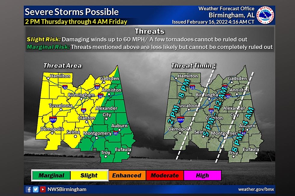
National Weather Service in Birmingham Highlights
Where:
Gusty non-thunderstorm winds: All of Central Alabama
Severe threat: All of Central Alabama
Tornado threat: Locations west of I-65 (lower tornado threat for areas east of I-65)
When:
Non-thunderstorm winds: 6 AM Thursday through midnight
Severe and Tornado Threat: 2 pm Thursday afternoon through 4 am Friday morning.
Threats:
Non-thunderstorm wind gusts of 30-45 MPH with locally higher gusts can bring down trees and powerlines.
Damaging straight-line winds up to 60 MPH are possible during thunderstorms.
A tornado or two cannot be ruled out.
James Spann, ABC 33/40, and Townsquare Media Tuscaloosa Chief Meteorologist provided more insight about the gradient wind factor. He mentioned that “strong south winds will develop across the state tomorrow (not related to thunderstorms) thanks to a tight pressure gradient. Winds will average 15-30 mph, with gusts to 40 mph possible. This could even bring some scattered tree and power line damage.”
(Source) For more from the National Weather Service Birmingham, click here. Click here to follow the Facebook Page for James Spann.
TIPS: Here's how you can prepare for power outages
Severe Weather Terminology You Should Know
KEEP READING: What to do after a tornado strikes
More From 105.1 The Block

