
Ian Strengthens, Alabama Coast Prepares for Possible Rough Surf, Rip Currents
Ian is now a Hurricane with winds of 75 miles per hour and the current tracking of this system is predicting that it will make the main impact over the Florida Peninsula.
It is forecasted to develop into a major hurricane and should make landfall Wednesday night just west of Tampa Bay. At this time, the thought is that Ian once inland will weaken but this means it will move slower.
Again, I always like to stress with hurricanes and tropical developments that many factors could change this information. We are keeping a constant watch on Ian.
What Does This Mean for Alabama?
The National Weather Service in Birmingham said that “based on the current forecast track from the National Hurricane Center, parts of east/southeast Alabama could see minor impacts from Ian. There is a margin of error that extends to the left and right (the cone). A track farther east would lessen the potential for impacts while a track farther west would tend to increase the potential for impacts.”

James Spann, ABC 33/40, and Townsquare Media Tuscaloosa Chief Meteorologist said that “Alabama and the Central Gulf Coast (Gulf Shores to Panama City Beach) will remain on the dry, offshore flow side of the circulation (the west side with a north wind). There could be some rain for extreme Southeast Alabama and possibly areas as far west as Panama City Beach, but the big impact in terms of the surge, heavy rain, and a tornado threat will be along and east of the circulation center, well to the east of Panama City Beach. The core concern is the Florida Peninsula, not the Panhandle.”

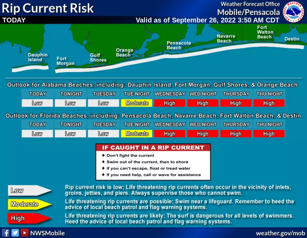
Those along the Central Gulf Coast should be prepared for very rough surf and rip current danger as well.
The National Weather Service in Mobile noted that a “swell associated with Ian will likely lead to DANGEROUS rip currents and surf along with rapidly building seas offshore by mid-week. Surf heights will rise rapidly Tuesday night into Wednesday and may persist later into the week. A MODERATE risk of rip currents is expected Tuesday night with a HIGH risk going into effect on Wednesday and continuing through Friday. It is too early to let our guard down about possible coastal flooding or surge impacts.”

(Source) Click here to follow the Facebook Page for James Spann. For more from the National Weather Service Birmingham, click here. For more from the National Weather Service Mobile, click here.
2022 Atlantic Hurricane Season Names
Gallery Credit: Mary K
Hurricane Terms You Need to Know
More From 105.1 The Block

