
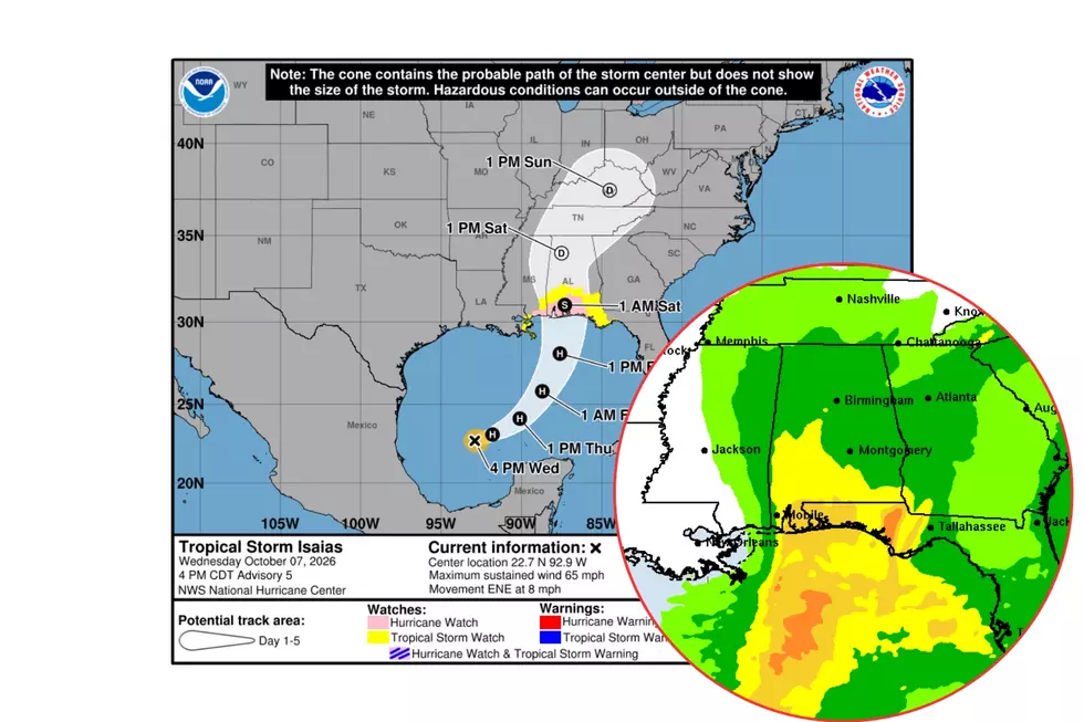
Isaias Could Strengthen into a Hurricane: What Alabama Can Expect
Tropical Storm Isaias is churning through the Gulf and is forecast to strengthen into a hurricane by Thursday morning, possibly reaching Category 2 before landfall on Friday evening.
As Isaias develops, we already know our area will see strong winds, heavy rainfall, and possible flooding.
Two other concerns are its track and speed. Why? The storm's track will also signal the potential for severe weather, including tornadoes. Speed also affects how quickly Isaias moves across the Yellowhammer State, leaving Alabama Crimson Tide fans on the edge for the Alabama–Georgia matchup on Saturday.
The Townsquare Media Weather Center is closely monitoring this developing weather situation very closely.

Current Details on Isaias
- Present movement is east-northeast
- The speed the system is tracking is 8 mph
- Winds are at 65 mph
- Estimated minimum central pressure is 994 MB
- Peak seas are near 11 ft
Let’s Talk Landfall
[NEW INFO] The potential landfall location has shifted again. “The updated track has been nudged eastward again; landfall is expected late Friday night just west of Pensacola Beach with winds of 90-100 mph,” said James Spann, Alabama Weather Network Chief Meteorologist.
Highlights from the National Weather Service in Birmingham
- Winds may gust as high as 40 to 50 mph late Friday night through Saturday, resulting in the potential for scattered to numerous downed trees and power lines.
- Rainfall amounts of 2 to 4 inches, with locally higher amounts up to 5 inches, will result in the potential for flash flooding, especially in urban and other poor drainage areas.
- A threat for isolated tornadoes may develop along and east of I-65 on Saturday, with the relatively highest potential in far southeastern portions of Central Alabama, but confidence remains low at this time.
Key Messages from the National Hurricane Center
- Isaias is expected to strengthen and be a strong hurricane when it approaches the northern Gulf Coast on Friday.
- There is an increasing risk of life-threatening storm surge along portions of the northern Gulf Coast.
- Isaias will bring areas of heavy rainfall to the central U.S. Gulf Coast and much of the Southeast Friday into the weekend.
- Flash and urban flooding, along with isolated river flooding, will be possible.
What about the Alabama–Georgia Football Game?
Spann said that “Models continue to trend faster. A good chance much of the rain will be over in time for the Alabama/Georgia game in Tuscaloosa.”
“There will still be a risk of showers at both venues, but not the widespread rain we will experience Saturday morning.”
Bottom line, speed is our friend, and let’s hope it’s on our side. – Mary K – Weather Forecaster.
LOOK: The top small towns for taking in America's fall foliage
Gallery Credit: Stacker
LOOK: Every state's nickname and where it comes from
Gallery Credit: Stacker
LOOK: The history behind all 63 national parks in the US
Gallery Credit: Stacker


