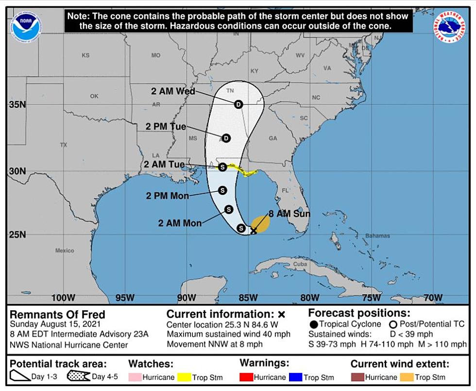
Fred Shifts Toward the East, Reaches Central Alabama Tuesday
Fred Headlines
Fred has shifted more towards the east in the latest track forecast.
Showing signs of reorganization in the southeastern Gulf of Mexico.
It is expected to restrengthen back into a tropical storm over the next 24 hours.
Predicted landfall over the northern Gulf Coast.
Increased threat of heavy rainfall over much of Central Alabama Monday Night and Tuesday.
Please remember that timing, the course of Fred, and impacts to our coverage area could change depending on how the system continues to redevelop today.
The National Weather Service Birmingham commented that “Fred continues to indicate that it will re-organize into a tropical storm today.” Also, the NWS notes that the main hazards for our coverage areas are “gusty winds and heavy rains.”
The National Hurricane Center states that a “turn toward the north expected on Monday. On the forecast track, the system will cross the southeastern Gulf of Mexico today, cross the east-central and northern Gulf of Mexico tonight and Monday, and move inland along the northern Gulf coast Monday night or early Tuesday morning.”

James Spann, ABC 33/40, and Townsquare Media Tuscaloosa Chief Meteorologist alerts us that “For inland Alabama, the heaviest rain will likely fall in areas south and east of Birmingham, where 2-3 inches are likely (especially across Southeast Alabama). Totals from Birmingham north and west will be generally 1/2 - 2 inches. Major flooding issues are not expected in Alabama at this point. For now, the tornado threat in Alabama looks very low.”
Fred Summary as of 7 a.m. central time zone
LOCATION…25.3N 84.6W
ABOUT 165 MI…265 KM WNW OF THE DRY TORTUGAS
ABOUT 390 MI…630 KM SSE OF PENSACOLA FLORIDA
MAXIMUM SUSTAINED WINDS…40 MPH…65 KM/H
PRESENT MOVEMENT…NNW OR 330 DEGREES AT 8 MPH…13 KM/H
MINIMUM CENTRAL PRESSURE…1009 MB…29.80 INCHES
Quick Note on Tropical Storm Grace
We will continue to monitor Grace as it is tracking to enter the Gulf of Mexico late in the week.
(Source) Click here for more from the National Weather Service Birmingham. Click here for more from The National Hurricane Center. Click here for more from James Spann.
LOOK: Stunning vintage photos capture the beauty of America's national parks
LOOK: Route 66’s quirkiest and most wonderful attractions state by state
See the Must-Drive Roads in Every State


