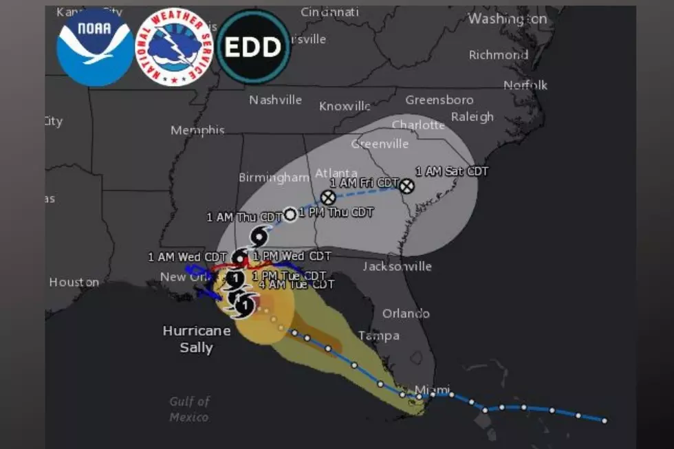
Hurricane Sally is Just Creeping Along
Hurricane Sally is Just Creeping Along

[Update: Tuesday, September 15, 2020, at 4:00 pm]
This afternoon update provides more details about the impacts of Hurricane Sally to Central Alabama.
• The National Weather Service has issued a Hazardous Weather Outlook - Wednesday and Thursday for the following counties: Marion-Lamar-Fayette-Winston-Walker-Blount-Etowah-Calhoun-Cherokee- Cleburne-Pickens-Tuscaloosa-Jefferson-Shelby-St. Clair-Talladega-Clay-Randolph-Sumter-Greene-Hale-Perry-Bibb-Chilton-Coosa-Tallapoosa-Chambers-Marengo-Dallas-Autauga-Lowndes-Elmore-Montgomery-Macon-Bullock-Lee-Russell-Pike-Barbour.
• The timing of Sally for Central Alabama will be Wednesday and Thursday. The system will impact areas near and south of I-59.
• There is still the threat of Flash Flooding that starts this evening and goes until Thursday. At this time, they are calling for 4 to 9 inches for the area.
• We could have breezy conditions where winds will reach 25 mph with wind gusts as fast as 45 mph.
• There is a threat for isolated, short-lived tornadoes Wednesday afternoon and evening. This could affect areas near and south of I-85.
• The National Weather Service encourages all residents in Central Alabama to stay informed about any potential weather conditions.
[Update: Tuesday, September 15, 2020, at 3:45 pm]
The National Weather Service has issued a Wind Advisory in Effect From 7 am Wednesday to 7 pm Thursday. East Winds Around 25 Mph Are Expected with Gusts 35 To 45 mph Possible. Near and South of a Line from Demopolis to Auburn.
Impacts...Gusty winds could blow around unsecured objects. Weaker trees and tree limbs could be blown down, and a few power outages may result.
Includes the following counties: Perry-Marengo-Dallas-Autauga-Lowndes-Elmore-Montgomery-Macon-Bullock-Lee-Russell-Pike-Barbour.
[Update: Tuesday, September 15, 2020, at 6:55 am]
Coastal cities between Louisiana to Florida are on edge as Hurricane Sally is now projected to make landfall tomorrow morning near the Mississippi and Alabama border. Sally is a slow-moving system, so slow that last night at 10 pm, it was moving at 3 miles per hour with 100 miles per hour winds.
Currently, Sally is a category one hurricane and is moving in a west and northwest pattern and even much slower at 2 miles per hour with 85 mph winds. [Sally is nearly stationary] Hurricane-force winds extend up to 45 miles, and tropical-storm-force winds extend up to 125 miles from the center. At this time, there is no expectation that Sally will gain any further strength.
We want you to be prepared, as the anticipation builds for the arrival of Hurricane Sally to Central Alabama. Hurricanes are unpredictable, and any slight change in track, timing, speed, and other variables could change the outcome for what to expect in our listening areas.
Central Alabama Impacts via the National Weather Service Birmingham
- Flash Flood Watch – 1 am Wednesday through 7 am Thursday
- Flooding: rainfall totals of 4” to 9”, locally higher
- River flooding risk for some area rivers
- Widespread tropical downpours across Central Alabama, especially south of I-20
- Winds: sustained 20 to 30 mph, gusts 40 mph, across the SW on Wednesday
- Tornadoes: marginal risk of a few brief tornadoes across the far south on Wednesday
The National Weather Service Birmingham encourages you to prepare now for flash flooding. On their Facebook page, they posted the following questions, “Are you in a flood plain? Do roads nearby flood easily?” Here is some advice they offer:
- Flash Flood Watch means be prepared. Flash flooding is possible
- Prepare for flooding before it happens.
- Monitor weather conditions closely
- Move to higher ground
- Be alert for flash flood warnings
Current Warnings and Watches:
A Storm Surge Warning is in effect for:
- The mouth of the Mississippi River to the Okaloosa/Walton County Line Florida
- Mobile Bay
A Hurricane Warning is in effect for:
- East of the Mouth of the Pearl River to the Navarre Florida
A Tropical Storm Warning is in effect for:
- East of Navarre Florida to Indian Pass Florida
- The mouth of the Pearl River westward to Grand Isle Louisiana, including Lake Pontchartrain and Lake Maurepas and metropolitan New Orleans
Active Hurricane Season:
Just a reminder that Hurricane season goes until November 30, 2020. We are currently in the middle of the peak of the hurricane season. For the record, in addition to Hurricane Sally, we have tropical storm Teddy, tropical storm Vicky, hurricane Paulette, and the last remnants of Rene. According to the Associated Press, this has “become one of the busiest hurricane seasons in history – so busy that forecasters have almost run through the alphabet of names with 2 ½ months still to go.”
More Hurricane Sally Related Stories from the Tuscaloosa Thread:
Be safe and stay weather aware. – Weather Forecaster – Mary K
(Source) For more from the National Weather Service Birmingham, click here to follow their Facebook page. For more from the Associated Press, click here.


