Severe Weather Update: West Alabama Upgraded to an Enhanced Risk
James Spann reported that “strong south winds will develop across the state tomorrow (not related to thunderstorms) thanks to a tight pressure gradient. Winds will average 15-30 mph, with gusts to 40 mph possible. This could even bring some scattered tree and power line damage.”
Click here for more information about the Wind Advisory for all of Central Alabama.
As this system moves towards Alabama, we are keeping a close watch on western Alabama and the damaging wind and tornado potential for our coverage areas. According to the Weather Channel, “low pressure is forecast to track from the Southern Plains into the Great Lakes while drawing warmer and increasingly more humid air into the South.”
RISK LEVEL UPGRADED
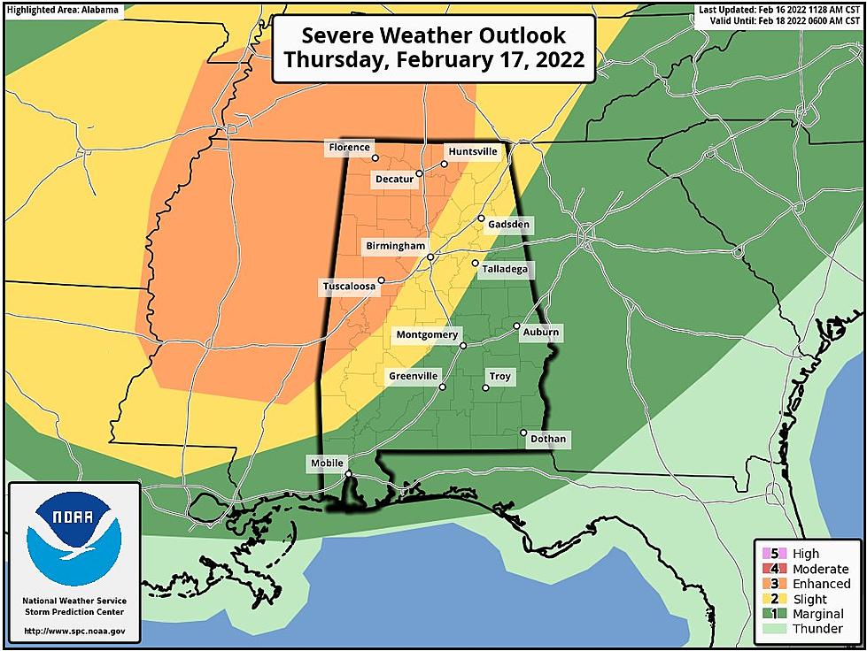
The Storm Prediction Center has upgraded North and West Alabama to an “enhanced risk” (level 3/5) of severe storms for tomorrow afternoon and evening.
Highlights from the National Weather Service in Birmingham
Where:
Gusty non-thunderstorm winds: All of Central Alabama
Severe threat: All of Central Alabama
Tornado threat: Locations west of I-65 and especially within the Enhanced Risk Area (lower tornado threat for areas east of I-65)
When:
Non-thunderstorm winds: 6 AM Thursday through midnight
Severe and Tornado Threat: 2 pm Thursday afternoon through 4 am Friday morning.
Threats:
Non-thunderstorm wind gusts of 30-45 MPH with locally higher gusts can bring down trees and powerlines.
Damaging straight-line winds of 60-70 MPH are possible during thunderstorms.
Tornadoes (Best chance within the Enhanced Risk Area)
Quarter size hail cannot be ruled out
BE PREPARED
Be sure to have a severe weather plan in place and multiple ways to receive warnings. The National Weather Service in Birmingham strongly encourages you to “BE PREPARED: Know your plan of action when a warning is issued for your location, including where your safe place is located. That could be the lowest floor, an interior room away from windows, or even your nearest storm shelter. Have more than one way to receive a warning.”

(Source) Click here for more information from the Storm Prediction Center. Click here for more details from the National Weather Service. For more from the Weather Channel, click here. Click here for more from James Spann.
KEEP READING: What to do after a tornado strikes
TIPS: Here's how you can prepare for power outages
KEEP READING: Get answers to 51 of the most frequently asked weather questions...
More From 105.1 The Block