Stay Aware: Potential Severe Weather On Wednesday
We are closely monitoring this potential for severe weather in our areas on Wednesday, April 6, 2022. This is a developing weather scenario and information could be adjusted as we get closer to the actual weather event.

Get our free mobile app
OVERVIEW:
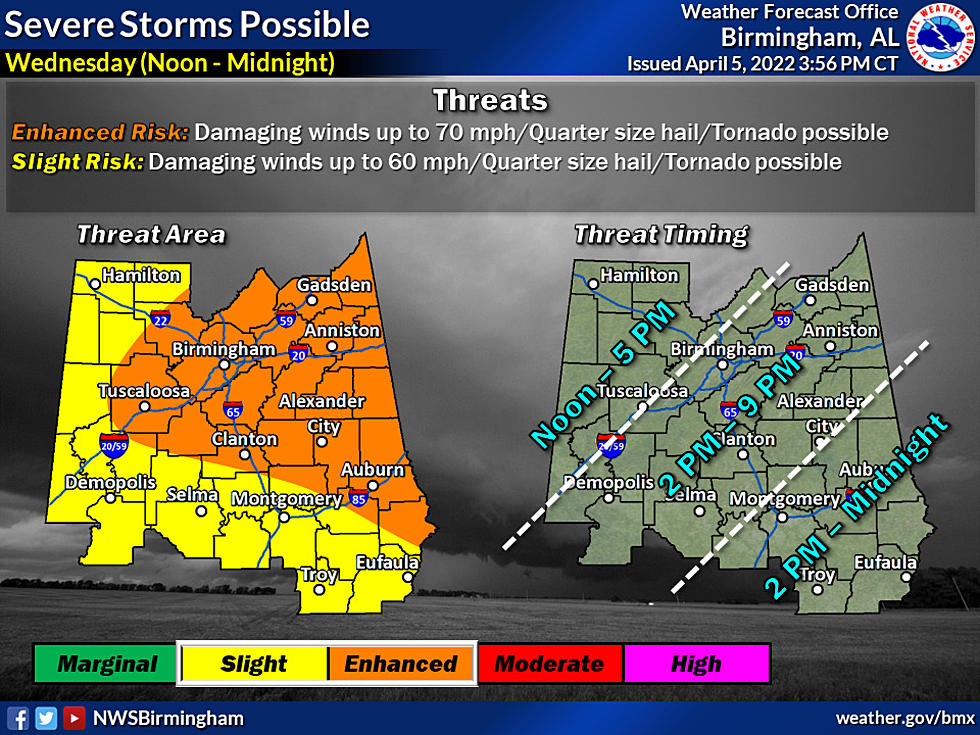
According to ABC 33/40 and Townsquare Media Tuscaloosa Chief Meteorologist James Spann, a cold front will push a band of storms through Alabama during the afternoon and evening hours. the Storm Prediction Center has places like Birmingham, Tuscaloosa, Anniston, Gadsden, Huntsville, and Fort Payne in an "enhanced risk" (level 3/5), while the rest of the state is in a "slight risk" (level 2/5).
THREATS:
Storms ahead of the cold front will be capable of producing large hail and strong winds. The tornado threat continues to look low due to a unidirectional wind profile, but if a small scale low can form along the front, an isolated tornado can't be totally ruled out. The storms will sweep through Alabama in the 3:00 p.m. to 9:00 p.m. time frame Wednesday.

According to the Alabama EMA, The main threat Wednesday will be damaging winds and heavy rainfall with some hail possible.
Townsquare Media Tuscaloosa will be providing you with nonstop live updates on the severe weather threat for Wednesday, April 6, 2022. You'll be able to find the latest information like threats, risk areas, and timelines. In addition, we will provide details on any watches and warnings that are issued.
Click here to follow the Facebook Page of James Spann.
Top Stories from the Tuscaloosa Thread (3/28 - 4/3)
16 of the Top Stories published by the Tuscaloosa Thread during the week of March 28th, 2022.
Gallery Credit: (Stephen Dethrage | Tuscaloosa Thread)
This 196 Square Foot Santa Rosa Beach, Florida Home is Quite Pricey
Gallery Credit: Mary K
Homes for Under 200K in Tuscaloosa County Alabama
Gallery Credit: Mary K
More From 105.1 The Block

![[Video] Central And West Alabama Impacted By Storms Tuesday Evening](http://townsquare.media/site/993/files/2022/03/attachment-IMG_3468.jpeg?w=980&q=75)